
~ Gadsden AL topo map, 1:250000 scale, 1 X 2 Degree, Historical, 1956, updated 1966
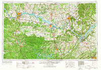
Gadsden, Alabama, USGS topographic map dated 1956.
Includes geographic coordinates (latitude and longitude). This topographic map is suitable for hiking, camping, and exploring, or framing it as a wall map.
Printed on-demand using high resolution imagery, on heavy weight and acid free paper, or alternatively on a variety of synthetic materials.
Topos available on paper, Waterproof, Poly, or Tyvek. Usually shipping rolled, unless combined with other folded maps in one order.
- Product Number: USGS-5542885
- Free digital map download (high-resolution, GeoPDF): Gadsden, Alabama (file size: 22 MB)
- Map Size: please refer to the dimensions of the GeoPDF map above
- Weight (paper map): ca. 55 grams
- Map Type: POD USGS Topographic Map
- Map Series: HTMC
- Map Verison: Historical
- Cell ID: 68793
- Scan ID: 305918
- Imprint Year: 1966
- Woodland Tint: Yes
- Edit Year: 1966
- Field Check Year: 1956
- Datum: Unstated
- Map Projection: Transverse Mercator
- Map published by United States Army Corps of Engineers
- Map published by United States Army
- Map Language: English
- Scanner Resolution: 600 dpi
- Map Cell Name: Gadsden
- Grid size: 1 X 2 Degree
- Date on map: 1956
- Map Scale: 1:250000
- Geographical region: Alabama, United States
Neighboring Maps:
All neighboring USGS topo maps are available for sale online at a variety of scales.
Spatial coverage:
Topo map Gadsden, Alabama, covers the geographical area associated the following places:
- Greenbrier - Irvington - Nitrate City - Bethel Grove - Mountain Grove - Batts Nest (historical) - Carrol Acres - Riverside - Mount Pleasant (historical) - Shady Grove (historical) - Grove Park - Echols Hill - Lot (historical) - Lakeview - Lingerlost - Anderson - Wyeth City - Ryan Crossroads - Half Acre Estates - Double Tree - Roberson Beach - Hanceville - Helicon - Gourdsville - Brooklyn - Southern (historical) - Russell Village - Street (historical) - Altoona - Morningdale - Saint Clair Store - Camp Spring (historical) - Palestine (historical) - Old Monrovia - Lawson - Grassy - Dells Vista Shores - Parkwood Estates - Lynntown - Rideout Village - Leath Gap (historical) - Hobbs Island - Loyall (historical) - Westmoreland (historical) - Rodentown - Upton (historical) - Kingtown - Flat Rock - Allens Crossroads - Greerton (historical) - Pikeville - Center Hill - Paradise Points - Butler Mill - Hollytree - Battleground - Morrow Acres - Cumberland Mountain Farm Colony (historical) - Brentwood - Donaldson Mill - Five Forks - Grove View Acres - Pleasant View - Cottonwood - Pine Acres - Pleasant Ridge - Turner Chapel - Mountain Mills (historical) - Brandontown - Fairview - Enon - Saint Florian - Rolling Woods - Sweetwater - Haden - Flemington Heights - Walker Woods - Fosters Mill - Lexington - Posey (historical) - Larkins Fork (historical) - East Sheffield - Lakeview Beach - Terrytown - Rock Springs - Twin Brooks - Sheffield Heights - Chase - Kildere Estates - Freeman Acres - Corbinville - Clarkdale - Bluff City - Aqua Vista - Oak Ridge - Sunset Acres - South Sauty Subdivision - Kaeiser Bottoms (historical) - Hepsidam - Norala Junction
- Map Area ID: AREA3534-88-86
- Northwest corner Lat/Long code: USGSNW35-88
- Northeast corner Lat/Long code: USGSNE35-86
- Southwest corner Lat/Long code: USGSSW34-88
- Southeast corner Lat/Long code: USGSSE34-86
- Northern map edge Latitude: 35
- Southern map edge Latitude: 34
- Western map edge Longitude: -88
- Eastern map edge Longitude: -86


