
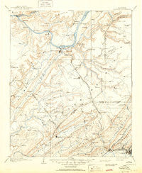
~ Gadsden AL topo map, 1:125000 scale, 30 X 30 Minute, Historical, 1903, updated 1950
Gadsden, Alabama, USGS topographic map dated 1903.
Includes geographic coordinates (latitude and longitude). This topographic map is suitable for hiking, camping, and exploring, or framing it as a wall map.
Printed on-demand using high resolution imagery, on heavy weight and acid free paper, or alternatively on a variety of synthetic materials.
Topos available on paper, Waterproof, Poly, or Tyvek. Usually shipping rolled, unless combined with other folded maps in one order.
- Product Number: USGS-5542741
- Free digital map download (high-resolution, GeoPDF): Gadsden, Alabama (file size: 7 MB)
- Map Size: please refer to the dimensions of the GeoPDF map above
- Weight (paper map): ca. 55 grams
- Map Type: POD USGS Topographic Map
- Map Series: HTMC
- Map Verison: Historical
- Cell ID: 65531
- Scan ID: 305840
- Imprint Year: 1950
- Survey Year: 1885
- Datum: Unstated
- Map Projection: Polyconic
- Map published by United States Geological Survey
- Map Language: English
- Scanner Resolution: 600 dpi
- Map Cell Name: Gadsden
- Grid size: 30 X 30 Minute
- Date on map: 1903
- Map Scale: 1:125000
- Geographical region: Alabama, United States
Neighboring Maps:
All neighboring USGS topo maps are available for sale online at a variety of scales.
Spatial coverage:
Topo map Gadsden, Alabama, covers the geographical area associated the following places:
- Hopper - Scant City - McVille - Corbinville - Smith Institute - New Home - Alexander Subdivision - Mountainboro - Howelton - Wynnville - Poplar Springs - Schuler (historical) - Mount Carmel - Warrenton Subdivision - Noble Hill - Reece City - Morton (historical) - Black Center - Scenic Heights - Harrisville - Playground Shores - Needmore - Southtown - Rayburn - Chigger Hill - Bartlett (historical) - North (historical) - Peters (historical) - Phillips (historical) - Miller Subdivision - Crudup - Lakeview - Minorville (historical) - Sunrise Shores - Jink (historical) - Columbus City - Moragne - Boaz - Mill Village - Geraldine - Sandy Point Subdivision - Agricola - Fridays Crossing - Mid (historical) - Black Creek Falls (historical) - Stanfield (historical) - Bowen (historical) - Hortons Mill - Albertville - Shady Acres - Sherwood Forest - Mount Hebron - Carlisle - Ferns Quarter (historical) - Skyhaven Estates - Hendrix - Red Apple (historical) - Thrasher Crossroads - Ellison Crossroads - Lewin (historical) - Hebron - Half Acre Estates - Lot (historical) - Neighbors Mill - Tuckahoe Heights - Lindsay Lane - Hustleville - Manchester - Asbury - Kilpatrick - Arab - Lattiwood - Nixon Chapel - Hide Away Acres - Snead - Alder Springs - Lane - Old Snead - Fenton - Walnut Grove - Double Bridges - Ivalee - Tanglewood - Grassy - Sardis City - Union Grove - Gregory (historical) - Pine Grove - Lamont (historical) - Whiton - Altoona - Gadsden - Bellevue - Bright Star - Pine Shores - Arona - Fowler (historical) - Holiday Shores - Hopewell - Haworth (historical)
- Map Area ID: AREA34.534-86.5-86
- Northwest corner Lat/Long code: USGSNW34.5-86.5
- Northeast corner Lat/Long code: USGSNE34.5-86
- Southwest corner Lat/Long code: USGSSW34-86.5
- Southeast corner Lat/Long code: USGSSE34-86
- Northern map edge Latitude: 34.5
- Southern map edge Latitude: 34
- Western map edge Longitude: -86.5
- Eastern map edge Longitude: -86


