
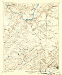
~ Gadsden AL topo map, 1:125000 scale, 30 X 30 Minute, Historical, 1903, updated 1936
Gadsden, Alabama, USGS topographic map dated 1903.
Includes geographic coordinates (latitude and longitude). This topographic map is suitable for hiking, camping, and exploring, or framing it as a wall map.
Printed on-demand using high resolution imagery, on heavy weight and acid free paper, or alternatively on a variety of synthetic materials.
Topos available on paper, Waterproof, Poly, or Tyvek. Usually shipping rolled, unless combined with other folded maps in one order.
- Product Number: USGS-5542739
- Free digital map download (high-resolution, GeoPDF): Gadsden, Alabama (file size: 7 MB)
- Map Size: please refer to the dimensions of the GeoPDF map above
- Weight (paper map): ca. 55 grams
- Map Type: POD USGS Topographic Map
- Map Series: HTMC
- Map Verison: Historical
- Cell ID: 65531
- Scan ID: 305839
- Imprint Year: 1936
- Survey Year: 1885
- Datum: Unstated
- Map Projection: Polyconic
- Map published by United States Geological Survey
- Map Language: English
- Scanner Resolution: 600 dpi
- Map Cell Name: Gadsden
- Grid size: 30 X 30 Minute
- Date on map: 1903
- Map Scale: 1:125000
- Geographical region: Alabama, United States
Neighboring Maps:
All neighboring USGS topo maps are available for sale online at a variety of scales.
Spatial coverage:
Topo map Gadsden, Alabama, covers the geographical area associated the following places:
- Saratoga - Bird (historical) - Ridgeville - Strawberry - Highmound - Honeycomb Park - Rollins (historical) - Fridays Crossing - Curtiston - Star Point Subdivision - Hebron - Mill Village - Riverside - Hustleville - Douglas - Pine Island Subdivision - Brans Chapel - Horton - Cushion - Skinner Subdivision - Boxtel - Shady Grove - Stanfield (historical) - Alder Springs - Arona - Summit - Agricola - Meadow Wood - Lane - Redbud - Peters (historical) - Ellison Crossroads - Johnsons Mill - Maryville - Lindsay Lane - Hide Away Acres - Morton (historical) - Haworth (historical) - Stowers Hill - Sidney - Wynnville - The Highlands - Whitesville - Sandy Point Subdivision - Black Creek Falls (historical) - Thirtynine (historical) - Little New York - Brooksville - Alexander Subdivision - Rogers - Aurora - Whitesboro - Marshall - Diamond - Egypt - Howelton - Tanglewood - Whiton - Guntersville - Cox Gap - Midway - Benson (historical) - Hortons Mill - Asbury - Geraldine - Walnut Grove - Bennettsville (historical) - Kyuka - Happy Hill - Fenton - Skyhaven Estates - Buck Island Subdivision - Union Grove - Sunrise Shores - Old Snead - Norton - Johnson - Pana - Warrenton - Smith Institute - Mountain View - Phillips (historical) - North (historical) - Upton (historical) - Ivalee - Miller Subdivision - Signal Point Subdivision - Black Center - Hopper - Craig (historical) - Pull Tight (historical) - Claysville - Hopewell - Gadsden - Hayes Branch Subdivision - Mid (historical) - Thrasher Crossroads - Cave Springs - Street (historical) - Guntersville Shores
- Map Area ID: AREA34.534-86.5-86
- Northwest corner Lat/Long code: USGSNW34.5-86.5
- Northeast corner Lat/Long code: USGSNE34.5-86
- Southwest corner Lat/Long code: USGSSW34-86.5
- Southeast corner Lat/Long code: USGSSE34-86
- Northern map edge Latitude: 34.5
- Southern map edge Latitude: 34
- Western map edge Longitude: -86.5
- Eastern map edge Longitude: -86


