
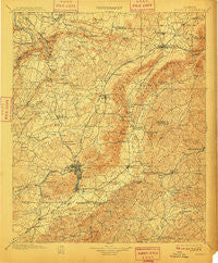
~ Anniston AL topo map, 1:125000 scale, 30 X 30 Minute, Historical, 1900, updated 1910
Anniston, Alabama, USGS topographic map dated 1900.
Includes geographic coordinates (latitude and longitude). This topographic map is suitable for hiking, camping, and exploring, or framing it as a wall map.
Printed on-demand using high resolution imagery, on heavy weight and acid free paper, or alternatively on a variety of synthetic materials.
Topos available on paper, Waterproof, Poly, or Tyvek. Usually shipping rolled, unless combined with other folded maps in one order.
- Product Number: USGS-5542659
- Free digital map download (high-resolution, GeoPDF): Anniston, Alabama (file size: 10 MB)
- Map Size: please refer to the dimensions of the GeoPDF map above
- Weight (paper map): ca. 55 grams
- Map Type: POD USGS Topographic Map
- Map Series: HTMC
- Map Verison: Historical
- Cell ID: 64889
- Scan ID: 305794
- Imprint Year: 1910
- Survey Year: 1898
- Datum: Unstated
- Map Projection: Unstated
- Map published by United States Geological Survey
- Map Language: English
- Scanner Resolution: 600 dpi
- Map Cell Name: Anniston
- Grid size: 30 X 30 Minute
- Date on map: 1900
- Map Scale: 1:125000
- Geographical region: Alabama, United States
Neighboring Maps:
All neighboring USGS topo maps are available for sale online at a variety of scales.
Spatial coverage:
Topo map Anniston, Alabama, covers the geographical area associated the following places:
- Hall Grove - Knightens Crossroads - Millie (historical) - Lardent - McCullars (historical) - Coldwater - Angel - Lenlock - Tallaseehatchee (historical) - Hicks - Abel - Sulphur Springs - Tarsus (historical) - Tooktocaugee (historical) - Spring Garden - Goshen (historical) - Zuni (historical) - Leydens Mill - Nisbit (historical) - Vigo - Mount Polk - Colwell - Burns Park - Knoxville - Ingram Wells - Sweet Home - West Wellington - Smiths Crossroads - Hill Top (historical) - Iron City - Arbacoochee (historical) - Heflin - Bonny Brook - Old Davisville - West Point - Morrisville - Clark (historical) - Webster Chapel - Letchers - Wellborn - Zula (historical) - Blue Springs (historical) - Grantley - Lakeview - Choccolocco - Pleasant Gap - Meadowbrook - Rock Spring - Asberry - Trinity - Ewing - Jenkins - Union - Laney - Pleasant Ridge - Meade (historical) - Irene (historical) - Gnatville - Spring Valley - Bethlehem - Germania Springs (historical) - Leatherwood - Middleton - Jo Dell - Richeytown - House (historical) - Sherman Heights - Hillcrest - Hokes Bluff - Hebron (historical) - Bera (historical) - Forest Hills - Burns Crossroad - Kearney (historical) - New Liberty - Midway (historical) - DeArmanville - Tarsus - Grant Town - Grayton - June Bug (historical) - Lowrimores Crossroads - Rabbittown - Booker T City - Anniston - Chinnabee (historical) - Saks - McKibben - Jacksonville - Halls Chapel - Colvin - Reads Mill - Prickettville - Glencoe - Joseph Springs - Boiling Spring - Mahlep - Reaves - Chulafinnee - Pine Grove
- Map Area ID: AREA3433.5-86-85.5
- Northwest corner Lat/Long code: USGSNW34-86
- Northeast corner Lat/Long code: USGSNE34-85.5
- Southwest corner Lat/Long code: USGSSW33.5-86
- Southeast corner Lat/Long code: USGSSE33.5-85.5
- Northern map edge Latitude: 34
- Southern map edge Latitude: 33.5
- Western map edge Longitude: -86
- Eastern map edge Longitude: -85.5


