
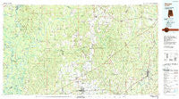
~ Atmore AL topo map, 1:100000 scale, 30 X 60 Minute, Historical, 1986, updated 1989
Atmore, Alabama, USGS topographic map dated 1986.
Includes geographic coordinates (latitude and longitude). This topographic map is suitable for hiking, camping, and exploring, or framing it as a wall map.
Printed on-demand using high resolution imagery, on heavy weight and acid free paper, or alternatively on a variety of synthetic materials.
Topos available on paper, Waterproof, Poly, or Tyvek. Usually shipping rolled, unless combined with other folded maps in one order.
- Product Number: USGS-5542573
- Free digital map download (high-resolution, GeoPDF): Atmore, Alabama (file size: 26 MB)
- Map Size: please refer to the dimensions of the GeoPDF map above
- Weight (paper map): ca. 55 grams
- Map Type: POD USGS Topographic Map
- Map Series: HTMC
- Map Verison: Historical
- Cell ID: 67079
- Scan ID: 305748
- Imprint Year: 1989
- Woodland Tint: Yes
- Aerial Photo Year: 1984
- Edit Year: 1986
- Datum: NAD27
- Map Projection: Universal Transverse Mercator
- Map published by United States Geological Survey
- Map Language: English
- Scanner Resolution: 600 dpi
- Map Cell Name: Atmore
- Grid size: 30 X 60 Minute
- Date on map: 1986
- Map Scale: 1:100000
- Geographical region: Alabama, United States
Neighboring Maps:
All neighboring USGS topo maps are available for sale online at a variety of scales.
Spatial coverage:
Topo map Atmore, Alabama, covers the geographical area associated the following places:
- Palmers Crossroads - Janes Mill - Keego - Drewry - Canoe - Robinsonville - Atmore - Lenox - Pineview - Alma - Wawbeek - Blacksher - Poarch - Belleville - Redtown - Malta - Homewood - Gainestown - Little River - Osaka - McCullough - Georgetown - Wagar - Mexboro - Fort Stoddard - Wallace - Eliska - Nichburg - Choctaw Bluff - Briar Lake Estates - Loree - Goodway - Chrysler - Tensaw - Pea Ridge - Stanley Crossroads - Carlton - East Brewton - Mount Pleasant - Spring Hill - Sardine - Little Rock - Riverview - Dixonville - Serange - Lottie - Raley Forest Hill - Jeddo - Mexia Crossing - Brantley Crossing - Fairview - Ewing Farms - Megargel - Huxford - Freemanville - Mount Gillis - Bermuda - Barnett Crossroads - Welka - Montgomery Hill - Wahl - Stokes - Sand Cut - Appleton - Castleberry - Kirkland - Jack Springs - Perdido - Rockville - Booneville - Flomaton - Martinville - Brewton - Repton - Pleasant Hill - Nokomis - Excel - Southern Estates - London - Pollard - Uriah - Latham - Ollie - Prestwick - Vaughn - Mineola - Hammac - Rabun - Manistee - Foshee - Barlow Bend - Carson - Range - Halls Crossroads - Frisco City
- Map Area ID: AREA31.531-88-87
- Northwest corner Lat/Long code: USGSNW31.5-88
- Northeast corner Lat/Long code: USGSNE31.5-87
- Southwest corner Lat/Long code: USGSSW31-88
- Southeast corner Lat/Long code: USGSSE31-87
- Northern map edge Latitude: 31.5
- Southern map edge Latitude: 31
- Western map edge Longitude: -88
- Eastern map edge Longitude: -87


