
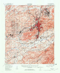
~ Anniston AL topo map, 1:62500 scale, 15 X 15 Minute, Historical, 1950, updated 1953
Anniston, Alabama, USGS topographic map dated 1950.
Includes geographic coordinates (latitude and longitude). This topographic map is suitable for hiking, camping, and exploring, or framing it as a wall map.
Printed on-demand using high resolution imagery, on heavy weight and acid free paper, or alternatively on a variety of synthetic materials.
Topos available on paper, Waterproof, Poly, or Tyvek. Usually shipping rolled, unless combined with other folded maps in one order.
- Product Number: USGS-5542155
- Free digital map download (high-resolution, GeoPDF): Anniston, Alabama (file size: 12 MB)
- Map Size: please refer to the dimensions of the GeoPDF map above
- Weight (paper map): ca. 55 grams
- Map Type: POD USGS Topographic Map
- Map Series: HTMC
- Map Verison: Historical
- Cell ID: 50594
- Scan ID: 305475
- Imprint Year: 1953
- Aerial Photo Year: 1946
- Field Check Year: 1950
- Datum: NAD27
- Map Projection: Polyconic
- Map published by United States Geological Survey
- Map published by United States Army Corps of Engineers
- Map published by United States Army
- Map Language: English
- Scanner Resolution: 600 dpi
- Map Cell Name: Anniston
- Grid size: 15 X 15 Minute
- Date on map: 1950
- Map Scale: 1:62500
- Geographical region: Alabama, United States
Neighboring Maps:
All neighboring USGS topo maps are available for sale online at a variety of scales.
Spatial coverage:
Topo map Anniston, Alabama, covers the geographical area associated the following places:
- Oxford - Bynum - Trinity - Hobson City - Lakeview - Gauldinville - McAding - Anniston - Sherman Heights - Meadowbrook - Hall Grove - Boiling Spring - Silver Run - Pelham Heights - Munford - Bera (historical) - De Soto Manor - Forest Hills - Lardent - Polkville (historical) - Wayside - Knoxville - Lenlock - Chinnabee (historical) - Sweet Home - Saks - McKibben - Hillcrest - Blue Pond - Tarsus (historical) - Richeytown - Letchers - DeArmanville - Morrisville - Coldwater - Vinnette - Woodland Park - Parkwood - Burns Crossroad - Meade (historical) - Blue Springs (historical) - Blue Mountain - Eulaton - Mahlep - Jenifer - Friendship - Tarsus - Mechanicsville - Obed (historical) - West End Anniston - Zula (historical) - Cobb Town - Jo Dell - New Haven - House (historical) - Spring Valley - Holly Springs - Cheaha Acres - Leatherwood - Bush - Kentuck - Peaceburg - Cane Creek - Golden Springs - Bethlehem - Hicks - Oxanna - Wellborn - Grant Town - Oak Hill
- Map Area ID: AREA33.7533.5-86-85.75
- Northwest corner Lat/Long code: USGSNW33.75-86
- Northeast corner Lat/Long code: USGSNE33.75-85.75
- Southwest corner Lat/Long code: USGSSW33.5-86
- Southeast corner Lat/Long code: USGSSE33.5-85.75
- Northern map edge Latitude: 33.75
- Southern map edge Latitude: 33.5
- Western map edge Longitude: -86
- Eastern map edge Longitude: -85.75


