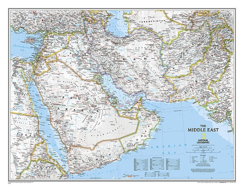
Middle East Classic Wall Map
National Geographics map of the Middle East covers a broad geographic area ranging from northern Africa through the Fertile Crescent to the western edge of China and India. Includes complete coverage of Afghanistan, Pakistan, Tajikistan, Iran, Iraq, Kuwait, Syria, Israel, Jordan, Lebanon, Saudi Arabia, Qatar, Bahrain, United Arab Emirates, Yemen, Oman, Cyprus, and Eritrea. Also includes parts of India, China, Kyrgyzstan, Uzbekistan, Turkmenistan, Azerbaijan, Armenia, Turkey, Egypt, Sudan, Ethiopia, and Djibouti.
Features thousands of place names, accurate political boundaries, archeological sites, and major infrastructure networks such as roads, canals, ferry routes, airports, and railroads. The regions diverse terrain is detailed through accurate shaded relief, coastal bathymetry, and symbolism for water features and other land forms. Elevations of major peaks and depth soundings are expressed in meters. The signature Classic style map uses a bright, easy to read color palett
- Product Number: NG_MIDDLE_WA_18
- Reference Product Number: 2032642M
- ISBN: 9780792281146
- Date of Publication: 6/1/2018
- Unfolded (flat) Size: 30.31 inches high by 23.62 inches wide
- Map format: Wall
- Map type: Trade Maps - Political
- Geographical region: Afghanistan,Armenia,Azerbaijan,Cyprus,Egypt,Eritrea,Georgia,Iran,Iraq,Israel,Jordan,Lebanon,Oman,Pakistan,Qatar,Saudi Arabia,Syria,Tajikistan,Turkey,Turkmenistan,United Arab Emirates,Uzbekistan,Yemen