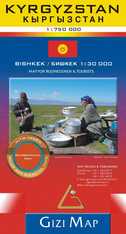
Krygyzstan Geographical Map by GiziMap
A very detailed geographical map of Kyrgyzstan at scale 1:750,000 ( 1 inch = 11.8 miles). The countrys mountainous terrain is depicted by bold elevation-tinting and spot heights with plenty of names of mountain ranges, peaks, valleys, etc. Added are graphics for swamps, salt flats and deserts. National parks are highlighted. The map shows internal provincial boundaries and also clearly indicates the countrys Uzbek and Tadjik enclaves.
Road network includes selected local tracks and highlights routes which used to be the part of the old Silk Road. Railway lines are included and local airports are marked. Symbols indicate various places of interest, locations with tourist accommodation including yurt camps, etc. Latitude and longitude lines are drawn at 30 intervals.
Two insets provide a street plan of central Bishkek annotated with important buildings, selected hotels and places of interest, plus a small administrative map of the country. The map has on the reverse two separate but cross-referenced indexes, in Latin and Cyrillic script. Multilingual map legend includes English. Paper map in cardboard protective cover.
- Product Number: 2143928M
- Product Code: GIZ_KYRG_GEOG
- ISBN: 9786155010125
- Year of Publication: 2014
- Folded Size: 9.45 x 5.12 inches
- Unfolded Size: 25.98 x 38.98 inches
- Map type: Folded Map
- Geographical region: Central Asia