
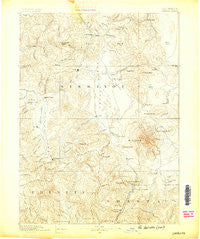
~ Shasta CA topo map, 1:250000 scale, 1 X 1 Degree, Historical, 1886
Shasta, California, USGS topographic map dated 1886.
Includes geographic coordinates (latitude and longitude). This topographic map is suitable for hiking, camping, and exploring, or framing it as a wall map.
Printed on-demand using high resolution imagery, on heavy weight and acid free paper, or alternatively on a variety of synthetic materials.
Topos available on paper, Waterproof, Poly, or Tyvek. Usually shipping rolled, unless combined with other folded maps in one order.
- Product Number: USGS-5618514
- Free digital map download (high-resolution, GeoPDF): Shasta, California (file size: 8 MB)
- Map Size: please refer to the dimensions of the GeoPDF map above
- Weight (paper map): ca. 55 grams
- Map Type: POD USGS Topographic Map
- Map Series: HTMC
- Map Verison: Historical
- Cell ID: 322292
- Scan ID: 299887
- Survey Year: 1885
- Datum: Unstated
- Map Projection: Unstated
- Map published by United States Geological Survey
- Map Language: English
- Scanner Resolution: 600 dpi
- Map Cell Name: Weed E
- Grid size: 1 X 1 Degree
- Date on map: 1886
- Map Scale: 1:250000
- Geographical region: California, United States
Neighboring Maps:
All neighboring USGS topo maps are available for sale online at a variety of scales.
Spatial coverage:
Topo map Shasta, California, covers the geographical area associated the following places:
- Leaf - Ager - Ranch Mobile Home Park - Dirigo - Walker - Bolam - Abrams Lake Mobile Estates - Pomeroy (historical) - Gibson - Foster - Oakbar - McCloud - Metcalf (historical) - Greenview - Signal Butte - Graham (historical) - Chateau Shasta Mobile Home Park - Rodney's Mobile Park - Cheeseville - Gottsville - Hooperville (historical) - Carrick - Little Shasta - Igerna - Henley - Fisher - Weed - Azalea - Mount Shasta - Edgewood - Howard - Cascade Sun Mobile Home Estates - Cal-ore Trail Mobile Estates - Esperanza (historical) - Horse Creek - Montague - Shasta Retreat - Shasta Springs - Black Butte - Cove Mobile Villa - Mount Hebron - Fort Jones - Cinnabar Springs (historical) - Yreka - Carrville - Klamath River - Grenada - Sweetbriar - Swiss Bar - Macdoel - Houston (historical) - Big Springs - Shadow Mountain Mobile Home Park - Andesite - Hooper - Horizon Hills Mobile Home Park - Ash Creek Junction - Beswick - Hilt - Wyntoon - Castle Crag - Deacon Lee Place - Riverwood Mobile Home Estates - Erickson - Gazelle - Conant - Oak Ridge Mobile Estates - Copco - Coffee - Sims - Logan - Pioneer - Oro Fino - Hawkinsville - Grass Lake - Jims Camp - Stringtown (historical) - Oaks Mobile Home And Recreational Vehicle Park - Dunsmuir - Cougar - Snowden - Nickels Mobile Park - Jerome - Warmcastle Mobile Home Park - Penoyar - Callahan - Deetz - Upton - Castella - Hornbrook - Hammond Ranch - Cantara (historical) - Hotlum - Rinckel - Etna - Coffee Creek - Mugginsville - Mott
- Map Area ID: AREA4241-123-122
- Northwest corner Lat/Long code: USGSNW42-123
- Northeast corner Lat/Long code: USGSNE42-122
- Southwest corner Lat/Long code: USGSSW41-123
- Southeast corner Lat/Long code: USGSSE41-122
- Northern map edge Latitude: 42
- Southern map edge Latitude: 41
- Western map edge Longitude: -123
- Eastern map edge Longitude: -122


