
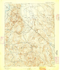
~ Markleeville CA topo map, 1:125000 scale, 30 X 30 Minute, Historical, 1893, updated 1893
Markleeville, California, USGS topographic map dated 1893.
Includes geographic coordinates (latitude and longitude). This topographic map is suitable for hiking, camping, and exploring, or framing it as a wall map.
Printed on-demand using high resolution imagery, on heavy weight and acid free paper, or alternatively on a variety of synthetic materials.
Topos available on paper, Waterproof, Poly, or Tyvek. Usually shipping rolled, unless combined with other folded maps in one order.
- Product Number: USGS-5505949
- Free digital map download (high-resolution, GeoPDF): Markleeville, California (file size: 10 MB)
- Map Size: please refer to the dimensions of the GeoPDF map above
- Weight (paper map): ca. 55 grams
- Map Type: POD USGS Topographic Map
- Map Series: HTMC
- Map Verison: Historical
- Cell ID: 74698
- Scan ID: 299438
- Imprint Year: 1893
- Survey Year: 1889
- Datum: Unstated
- Map Projection: Unstated
- Map published by United States Geological Survey
- Map Language: English
- Scanner Resolution: 600 dpi
- Map Cell Name: Markleeville
- Grid size: 30 X 30 Minute
- Date on map: 1893
- Map Scale: 1:125000
- Geographical region: California, United States
Neighboring Maps:
All neighboring USGS topo maps are available for sale online at a variety of scales.
Spatial coverage:
Topo map Markleeville, California, covers the geographical area associated the following places:
- Kingsbury Village - Shay Creek Summer Home Area - Tahoe Village - Loope - Round Hill - Fredericksburg - Dresslerville - Mountain House (historical) - Markleeville - Valley View (historical) - Elk Point - Carman Heights - South Lake Tahoe - Sheridan - Mammoth Ledge (historical) - Mount Bullion (historical) - Paynesville - Topaz - Stateline - Al Tahoe - Walleys Hot Springs - Stateline - Alpine Village - Centerville - Hobart (historical) - Kingsbury Meadows - Kingsbury - Double Springs (historical) - Minden - Sorensens - Topaz Lake - Mesa Vista - Gardnerville Ranchos - Mottsville - Buckeye - Gardnerville - Bijou Park - Twelvemile House - Fountain Place - Woodfords - Summit Village - Coleville - Marklee Village - Bijou - Centerville (historical) - Holbrook Junction - Edgewood - Silver Mountain (historical)
- Map Area ID: AREA3938.5-120-119.5
- Northwest corner Lat/Long code: USGSNW39-120
- Northeast corner Lat/Long code: USGSNE39-119.5
- Southwest corner Lat/Long code: USGSSW38.5-120
- Southeast corner Lat/Long code: USGSSE38.5-119.5
- Northern map edge Latitude: 39
- Southern map edge Latitude: 38.5
- Western map edge Longitude: -120
- Eastern map edge Longitude: -119.5


