
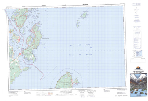
021B15 Campobello Island Canada topo map, 1:50,000 scale
021B15 Campobello Island NRCAN topographic map.
Includes UTM and GPS geographic coordinates (latitude and longitude). This 50k scale map is suitable for hiking, camping, and exploring, or you could frame it as a wall map.
Printed on-demand using high resolution, on heavy weight and acid free paper, or as an upgrade on a variety of synthetic materials.
Topos available on paper, Waterproof, Poly, or Tyvek. Usually shipping rolled, unless combined with other folded maps in one order.
- Product Number: NRCAN-021B15
- Parent Topo: TOPO-021B
- Map ID also known as: 021B15, 21B15
- Unfolded Size: Approximately 26" high by 36" wide
- Weight (paper map): ca. 55 grams
- Map Type: POD NRCAN Topographic Map
- Map Scale: 1:50,000
- Geographical region: New Brunswick, Canada
Neighboring Maps:
All neighboring Canadian topo maps are available for sale online at 1:50,000 scale.
Purchase the smaller scale map covering this area: Topo-021B
Spatial coverage:
Topo map sheet 021B15 Campobello Island covers the following places:
- Baie de Fundy - Bay of Fundy - Bay of Fundy - Big Whale Cove - Brandy Cove - Chocolate Cove - Clam Cove - Clarks Cove - Coates Cove - Conroy Cove - Cummings Cove - Curry Cove - Dark Harbour - Deep Cove - Deep Gulch Cove - Dinner Cove - Doctors Cove - Eastern End Cove - Eastern Head Cove - Flagg Cove - Friar Bay - Friar Roads - Friars Bay - Great Duck Pond - Harbour de Lute - Harbour Lute - Head Harbour - Herring Bay - Herring Cove - Hibernia Cove - Johns Cove - Leonardville Harbour - Liberty Cove - Little Whale Cove - Long Island Bay - Lower Duck Pond - Meadow Brook Cove - Mill Cove - Mill Cove Creek - Money Cove - North Harbour - Northern Harbour - Northwest Harbour - Otter Cove - Passamaquoddy Bay - Pauls Cove - Paul's Cove - Pettes Cove - Pollock Cove - Quoddy Road - Quoddy Roads - Ragged Cove - Sawpit Cove - Sawyers Cove - Schooner Cove - Ship Cove - Snug Cove - Southern Cove - Southwest Cove - The Gully - Union Cove - Welch Creek - Whale Cove - Bull Dog Beach - Dunn Beach - Friars Bay Beach - Gardners Beach - Herring Cove Beach - Indian Beach - Indian Beach - Little Ship Beach - Mallock Beach - Raccoon Beach - Red Beach - Ship Beach - Whistle Beach - Wilsons Beach - Ashburton Head - Bald Head - Birch Point - Brandy Head - Brown Head - Calders Head - Charleys Point - Clam Cove Head - Clines Point - Cranberry Point - Cubs Point - Deer Island Point - Deer Point - Deer Point - Dinner Head - Duck Point - East Quoddy Head - Eastern Head - Fish Head - Friar Head - Friars Head - Gardners Point - Gilligan Point - Gooseberry Point - Graveyard Point - Herring Bay Head - Indian Head - Liberty Point - Long Eddy Point - Long Point - Longs Eddy Point - Man of War Head - McKenzies Point - Mill Cove Point - Mink Point - Mink Point - Mulholland Point - Nancy Head - Net Point - Northern Head - Oak Head - Owen Head - Pea Point - Poors Point - Raccoon Point - Ragged Point - Red Head - Scott Head - Southern Head - Swallow Tail - The Dock - Wilsons Head - Wilsons Point - Windmill Point - Hole in the Wall - Grand Manan Channel - Head Harbour Passage - Lubec Channel - Lubec Narrows - Quoddy Narrows - Western Passage - Seven Days Work - Whiterock Cliffs - Campobello - Charlotte - West Isles - Bains Island - Bar Island - Bean Island - Beans Island - Campobello Island - Casco Bay Island - Casco Island - Cherry Island - Cherry Islet - Deer Island - Dinner Island - Dinner Islet - Duck Islands - East Wolf Island - Eastern Wolf Island - Fatpot Island - Flat Wolf Island - Flat Wolf Island - Grand Manan - Grand Manan Island - Green Island - Green Rock - Head Harbour Island - Hospital Island - Hospital Islands - Indian Island - Little Island - Marble Island - Mink Island - Mowat Island - Nubble Island - Pope Islet - Popes Island - Rouen Islet - Sandy Island - Simpsons Island - South Wolf Island - Southern Wolf Island - Spectacle Island - Spectacle Island - Spectacle Islands - Spruce Island - Spruce Island - St. Helena Island - The Pup - The Specs - The Wolves - Thrumcap Island - Thumb Cap - Tinker Islet - Tinkers Island - White Horse Island - White Horse Islet - White Island - Beals Eddy Pond - Big Pond - Dicks Pond - Eastern Pond - Eel Lake - Hopper Pond - Jack Sinclair Pond - Lake Glensevern - Leonards Lake - Lily Pond - Little Duck Pond - Little Lake - Little Pond - Mill Cove Pond - Ohio Pond - Rich Pond - Southern Cove Pond - Upper Duck Pond - Whale Beach Pond - Wilson Pond - Barrow Well Hill - Beech Hill - Bucks Mountain - Bunker Hill - Cates Lookout - Coke Hill - Coldkill Hill - Daddy Good Mountain - Dunbar Hill - Dunbar Hill - Eagle Mountain - Fox Hill - Hanna Dow Hill - Hannabury Hill - Petes Hill - Raccoon Hill - Spragues Hill - Stovers Hill - Welch Hill - Herring Cove Provincial Park - Parc international Roosevelt Campobello - Roosevelt Campobello International Park - New Brunswick - Nouveau-Brunswick - The Old Sow - Carr Brook - Dark Harbour Brook - Dock Brook - Eel Brook - Grand Brook - Hibernia Brook - Hopper Brook - Leonards Brook - Mill Creek - Mill Stream - Money Cove Brook - Stanley Brook - Indian River - Quoddy River - Argument Shoals - Back Cove Ledges - Bag Ledge - Bains Ledges - Beans Ledges - Black Rock - Boil Rock - Bowens Rock - Butlers Ledge - Buttermilk Rock - Chain Ledge - Cod Rock - Dinner Island Ledge - Dinner Islet Ledge - Duck Rock - East Rock - Flaggs Bank - Gooseberry Ledges - Green Island Shoal - Green Islet Shoal - Growler Ledge - Gull Rock - Gun Rock - Halftide Ledge - Halibut Ledges - Head Harbour Ledges - Horseshoe Rock - Inner Middle Ground - Krabble Rock - Little White Horse Ledges - Middle Ground - Molasses Rock - Mourners Delight - Nancy Rock - Net Ledges - Net Rocks - New England Ledge - North Rock - Nubble Ledge - Owen Basin - Parker Ledges - Pompey Ledges - Pope Shoal - Popes Shoal - Racer Rock - Round Rock - Sandy Island Ledge - Sandy Ledge - Seal Rock - Simpsons Ledge - Split Rock - St. Helena Ledges - Stovers Ledge - Sugar Loaf Rock - The Bishop - The Boring Stone - The Nubble - The Nubble - Tinkers Lower Ledge - Tinkers Upper Ledge - Turks Rock - Two Hour Rock - Upper Sandy Ledges - Chocolate Cove - Cummings Cove - Fairhaven - Indian Island - Leonardville - Lords Cove - Malloch Beach - North Harbour - North Head - North Road - Northern Harbour - Otter Cove - Richardson - Rocky Corner - Tattons Corner - Welshpool - Wilsons Beach - Abrahams Plain - Petes Meadow - Grand Manan


